Second mission to scale deep mountains announced

Scientists are set to begin a six-week mission to explore the Indian Ocean’s underwater mountains.

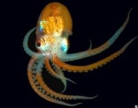
Aboard the UK research vessel the RRS James Cook, the team will study animals thousands of metres below the surface.

This year a report in the journal Marine Policy found that deep sea trawling is one of the most damaging forms of fishing.

The expedition will help scientists to better understand the threats to this environment.

The mission, led by the International Union for Conservation of Nature (IUCN), is the second to visit the seamounts along the South-West Indian Ocean Ridge; the first set out in November 2009.

Seamounts are underwater mountains which rise to at least 1,000 metres above the sea floor.

Seamount communities

“Because of their interactions with underwater currents, the biodiversity that develops around them is remarkably rich,” explained Aurelie Spadone, IUCN’s marine programme officer and a member of the team.

“They attract a great diversity of species and act as a type of ‘bed and breakfast’ for deep-sea predators such as sharks, which often feed on seamount communities,” she added.

The catch of deep-sea species has increased seven-fold since the mid-1960s, as stocks of shallower waters plummet and the fishing industry took to exploiting deeper waters.

Industrial fishing at depth, which generally relies on trawling the ocean’s bottom with huge weighted nets, has a huge impact on seafloor ecosystems, say researchers.

Carl Gustaf Lundin, director of IUCN’s Global Marine and Polar Programme explained that very little was known about the species associated with seamounts.

“Many of them grow and reproduce slowly, which makes them particularly vulnerable to overexploitation,” he said.

“Deep-sea bottom fisheries, including bottom trawling, can damage seamount habitats and negatively impact fish stocks. It can also irreversibly damage cold water corals, sponges and other animals.”

Alex Rogers of the University of Oxford and chief scientist on board RRS James Cook said: “We’re hoping that this expedition will help us better understand this unique marine life and assess the threats it faces.

:: Read original here ::
Icelandic rocks could have steered Vikings

Vikings used rocks from Iceland to navigate the high seas, suggests a new study.

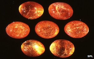
In Norse legends, sunstones are said to have guided seafarers to North America.

Now an international team of scientists report in the journal the Proceedings of the Royal Society Athat the Icelandic spars behave like mythical sunstones and polarise light.

By holding the stones aloft, voyaging Vikings could have used them to find the sun in the sky.

The Vikings were skilled navigators and travelled thousand of kilometres between Northern Europe and North America.

But without a magnetic compass, which was not invented until the 13th Century, they must have relied on other navigational aids.

Without the stars, which would have been out of sight during the constant daylight of the summer months, the sun would have been their best bet to set their course by.

But on cloudy or foggy days the seafarers would have been left with only the direction of the wind and swell to guide their way.

Through the fog

Norse legends tell of seafarers lifting stones to the sky to spy the direction of the sun when it was hidden by cloud cover.

Earlier this year, a study in the Philosophical Transactions of the Royal Society B reviewed the evidence that naturally forming crystals can selectively block light of one polarisation – how waves of light can be restricted to certain directions of oscillation.

The new result shows that Icelandic spars, which are formed from crystallised calcium carbonate, are good polarisers and could have been the raw material of the mythical sunstones.

The spars can be easily cleaved and crafted into a rhombus shape required for the polarising effect, and the discovery of one on the wreck of an Elizabethan ship that sunk in 1592 “looks very promising” the authors report.

:: Read original here ::

Marine Mud Is High in Fish Poop


Will you still enjoy feeling the beach between your toes this summer knowing it’s partly fish feces? In a paper published online this week in the Proceedings of the National Academy of Sciences, researchers report that 14% of the calcium carbonate that makes up the muddy floors of shallow tropical seas is fish poop. Fecal samples from 11 common tropical fish, including barracudas and snappers, reveal that calcium carbonate forms a key component of the excrement. The team estimates that every year, tropical fish excrete 6.1 million kilograms of calcium carbonate, equivalent to the weight of 1000 adult elephants, over an area of 111,577 square kilometers. Each fish may even have its own unique “fecalprint”, with specific sizes and shapes of calcium carbonate crystals (as seen in the black and white image), which could allow future oceanographers to analyze an ocean’s mud to track changes in the numbers and diversity of fish species.

:: Read original here ::

Early rocks to reveal their ages

Rock2

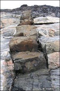
A new technique has been helping scientists piece together how the Earth’s continents were arranged 2.5 billion years ago.

The novel method allows scientists to recover rare minerals from rocks.

By analysing the composition of these minerals, researchers can precisely date ancient volcanic rocks for the first time.

By aligning rocks that have a similar age and orientation, the early landmasses can be pieced together.

This will aid the discovery of rocks rich in ore and oil deposits, say the scientists. The approach has already shown that Canada once bordered Zimbabwe, helping the mining industry identify new areas for exploration.

Dr Wouter Bleeker, from the Geological Survey of Canada, explained that much of the geology that exists today formed around 300 million years ago when the supercontinent Pangea existed.

“We really don’t understand the [Earth’s] history prior to Pangea,” he told a recent meeting of the American Geophysical Union in Toronto.

Early landmasses

Analysis of rocks that formed when continents drifted apart can help geologists reconstruct early landmasses.

Dr Richard Ernst, a geologist from the University of Ottawa, explained that molten magma fills the cracks formed by shifting continental plates.

The magma cools to form long veins of basalt – a volcanic rock – that has a “distinct magnetic signature” revealing the rock’s orientation and latitude when it formed.

By combining this “magnetic signature” with the ages of these rocks, researchers can tell whether rocks on different continents were once part of the same volcanic up-welling.

But until now, researchers have been unable to determine the ages of many of these ancient rocks because of the difficulty in extracting the minerals used to date them.

“We are dealing with such small mineral crystals – typically much less than 100 microns long – we are talking about grains far smaller than the width of a human hair,” explained Dr Michael Hamilton, a geologist and co-leader on the project.

But with the development of new techniques, minerals – such as baddeleyite – can now be successfully recovered.

Baddeleyite is useful because it incorporates large amounts of uranium into its crystal-structure, and because uranium naturally decays to lead. Scientists also know the rate at which this happens.

“[They] can use these minerals as radioactive clocks,” Dr Hamilton added.

“All we need to do is measure the the amounts of uranium and lead very precisely.”

In a large, international project, researchers hope to collect and date 250 rocks from around the world, and use this information to reconstruct how these continental fragments were once together to form giant landmasses that existed 2.5 billion years ago.

:: Read original here ::

Space rock yields carbon bounty

Formic acid, a molecule implicated in the origins of life, has been found at record levels on a meteorite that fell into a Canadian lake in 2000.

Cold temperatures on Tagish Lake prevented the volatile chemical from dissipating quickly.

An analysis showed four times more formic acid in the fragments than has been recorded on previous meteorites.

The researchers told a meeting of the American Geophysical Union that the formic acid was extraterrestrial.

Formic acid is one of a group of compounds dubbed “organics”, because they are rich in carbon.

“We are lucky that the meteorite was untouched by humans hands, avoiding contamination by organic compounds that we have on our fingers,” said Dr Christopher Herd, the curator of the University of Alberta’s meteorite collection.

Samples of the meteorite totalling 850 grams were collected from Tagish Lake in Canada, purchased in 2006 by a consortium including the Royal Ontario Museum and recently subjected to chemical analysis.

The scientists found levels of formic acid four times higher than had previously been recorded on a meteorite. Studies have until recently focused on the Murchison meteorite that landed in a town of that name in Australia in 1969.

“The interesting thing is that we do see this variability between meteorites, seeming to have increased enrichments of one particular compound over another,” said Mark Sephton, a meteorite and geochemistry professor at Imperial College London.

“This has for a while been overlooked as we concentrated predominantly on the Murchison meteorite, but now we’ve got another fresh sample and we can start to analyse a different portion of the asteroid belt and therefore a different portion of the Solar System.”

Primordial kitchen

The particular types, or isotopes, of hydrogen that are found in the formic acid show that it most likely formed in the cold regions of space before our Solar System existed.

On Earth, formic acid is commonly found in the stings of insects such as ants, but Professor Sephton said it is likely to have been an important “ingredient in the kitchen” on Earth before life began.

The acid is known to act as a “reducing agent” – acting as a magnet for oxygen atoms during chemical reactions – and facilitate the conversion of some amino acids into others.

It may also be implicated in the transformation of the more primitive RNA into DNA.

Only one of the four “nucleobases” that make up RNA and DNA is different between the two: uracil is present in RNA while thymine takes its place in DNA.

Professor Sephton’s team found uracil in the Murchison meteorite, but no measurable amount of thymine. However, formic acid is known to help along the reaction that converts the uracil into thymine.

The reaction, he said, is “one of the ways in which you can take some simple molecules and increase the chemical diversity of the pool of pre-biotic molecules”.

:: Read original here ::

Ocean mission delivers first maps

Less than a month after it was put in orbit, the ocean-mapper Jason-2 has returned its first pictures to Earth.

From an altitude of more than 1,300km, the spacecraft is now feeding back data covering nearly the entire globe.

Jason-2 is set to become the primary means of measuring the shape of the world’s oceans, taking readings with an accuracy of better than 4cm.

The information will be crucial to our understanding of both sea level rise and changing ocean currents.

The satellite is now flying in tandem with its predecessor, Jason-1.

The spacecraft, only 55 seconds apart, are making simultaneous measurements of the oceans’ “hills” and “valleys”, to allow precise calibration of Jason-2’s instruments.

Jason-2 (CNES)

The Jason Ocean Surface Topography Mission is led by the US and France

With everything in line, data collected with every circumnavigation of the Earth will help weather and climate agencies make better forecasts.

Jason-2, built by Thales Alenia Space, represents the joint efforts of the US and French space agencies (Nasa and CNES), and the US and European organisations dedicated to studying weather and climate from orbit (Noaa and Eumetsat).

Its key instrument is the Poseidon 3 solid-state altimeter. It constantly bounces microwave pulses off the sea surface.

By timing how long the signal takes to make the return trip, it can determine sea surface height. Additionally, the signal can indicate the height of waves and wind speed.

Elevation is a critical parameter for oceanographers. Just as surface air pressure reveals what the atmosphere is doing above, so ocean height will betray details about the behaviour of water down below.

Jason data gives clues to temperature and salinity. When combined with gravity information, it will also indicate current direction and speed.

The Jason lineage shows that mean sea level has been rising by about 3mm a year since 1993.

Jason-1 will continue to operate for as long as it is returning reliable data.

:: Read original here ::

Geological mapping gets joined up

The world’s geologists have dug out their maps and are sticking them together to produce the first truly global resource of the world’s rocks.

The OneGeology project pools existing data about what lies under our feet and has made it available on the web.

Led by the British Geological Survey (BGS), the project involved geologists from 80 nations.

Between 60% and 70% of the Earth’s surface is now available down to the scale of 1:1,000,000.

“That’s 1cm for every 10km of the Earth’s surface,” explained Ian Jackson from the BGS and leader of the OneGeology Project.

“With that resolution, people can focus in on a small part of their city.

Geological globe (CGMW)

The project pools existing data on the world’s rocks

“Eventually, people will be able to get up close and see the rocks beneath their house.”

Mr Jackson said this was because the geological maps were being constantly updated.

“Every time someone bores a hole in the ground, and hauls out some rock, we can refine our maps a little bit more.”

Project organisers explained that what is novel about this project is that it takes local geological information and makes it global.

Useful rocks

The resource displays geological information with the use of a “virtual globe”, in much the same way as Google Earth now presents satellite images.

Eventually, it is hoped that the geological maps will be detailed enough to help companies find the Earth’s exploitable resources, such as minerals and oil.

Mr Jackson suggested that the project should encourage the mining of minerals in developing countries, by making maps available that were previously unavailable to outside investors.

The developers of the system added that it would also help scientists and engineers learn more about the Earth and its environmental changes.

“Rocks are not inert, they influence the supply of water and the formation of soil, and so impact flooding and agriculture.”

How low can you go?

Researchers at the BGS hope that by making geological surveys global, they can encourage “big science” – research that no one country or geological survey could do on its own.

By crossing national borders, the “joined-up geology” should foster international initiatives that will target global problems, such as climate change.

“Geological surveys across the world are involved in trying to work out how you put CO2 underground and keep it there, and these sorts of databases are going to be required.”

At present, most of the globe is available at the scale of 1:1,000,000.

“However, some nations take the view that 1:1,000,000 is too commercially sensitive to release,” conceded Mr Jackson.

“Other parts of the world have not been mapped thoroughly enough to give us the resolution we would like.”

The project is the first global geological map that is constantly updated, so the resolution will only get better. In France and Britain, users of the OneGeology resource can already look at the rocks that lie directly beneath their feet in 3D.

:: Read original here ::

Sub to make deep Caribbean dive

Scientists are set to explore the world’s deepest undersea volcanoes, which lie 6km down in the Caribbean.

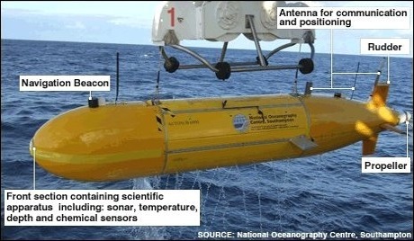
Delving into uncharted waters to hunt for volcanic vents will be Autosub6000, Britain’s new autonomously controlled, robot submarine.

Once found, the life, gas and sediment around the vents – the world’s hottest – will be sampled and catalogued.

The research will be carried out by a British team aboard the UK’s latest research ship, the James Cook.

“We are heading out on two expeditions, each close to a month long, to map the full length of the Cayman Trough,” said team leader, Dr Jon Copley of the National Oceanography Centre in Southampton (NOCS).

Dr Copley explained that the Cayman Trough, which lies between Jamaica and the Cayman Islands, is a product of the Caribbean tectonic plate pulling away from the American plate.

“It is the world’s deepest volcanic ridge and totally unexplored,” the Southampton-based researcher told BBC News.

Along with Autosub6000, the researchers will also rely on Isis, the UK’s deepest-diving, remotely operated vehicle to scan the deep.

Double Sub

First overboard will be Autosub6000, an unmanned undersea vehicle that can go down to 6,000m and carry out a dive without being controlled from the surface.

It will be tasked with finding the volcanic vents on the ocean floor.

The second submarine to take the plunge will be the Isis.

Isis will sample fluids and sediments from around the lip of the vents to test their geochemistry, and also collect animal specimens.

Map

Britain’s new robot sub will map the entire length of the Cayman Trough

“We are hoping to find several different types of vents along the ridge,” said Dr Copley.

“Some of the vents will be very similar in depth to the vents we already know about, and because the conditions will be alike, we might expect very similar animals,” he explained.

The researchers will look to compare the animals around the Cayman vents with those in the Atlantic and Pacific, in the hope of better understanding the processes that affect how deep-sea creatures “get about”.

If the organisms in the Cayman Trough look like those from other deep volcanic trenches, it will suggest that ocean currents must play a role in shaping the patterns of deep-sea life by transporting the animals’ larvae around.

However, if the Cayman Trough animals are very different from those existing in other parts of the Earth’s oceans then isolation will be considered more important.

“The deep ocean is our planet’s largest ecosystem. If we are going to use its resources responsibly then we need understand what determines its patterns of life,” the Southampton-based researcher said.

New vents

Dr Copley told BBC News that there was also another kind of venting that was driven by a very different geological process in which the Earth’s mantle is directly exposed to the water.

Arm/NOCS

The researchers will explore vents looking for deep-sea animals

This type of volcanism has only ever been seen once before, in the mid-Atlantic.

The temperatures around these hydrothermal vents were so hot because they were so deep, Dr Copley said.

“They could be hotter than 500C (930F), and if they are that hot, they will probably have quite different chemistry and life forms – we expect to find new species.”

The researchers expect that, at depths greater than 3,000m, one in every two animals they come across will be a species new to science.

:: Read original here ::